A Similar Boeing 727 (Richard Silagi [GFDL (http://www.gnu.org/copyleft/fdl.html)])Trans-World Airlines (TWA) Flight 514 was a regularly scheduled flight from Indianapolis, Indiana, to Washington, DC, with a stopover in Columbus, Ohio. On December 1, 1974, the flight was serviced by a Boeing 727-231, tail number N54328. It departed from Indianapolis International Airport on-time at 8:53 a.m. and arrived at Port Columbus International Airport without incident at 9:32 a.m.
The captain of Flight 514 on that day was Richard I. Brock, an experienced pilot with over 3,700 flight hours as captain or first officer and another 3,100 hours as a flight engineer. The first officer was Lenard K. Kresheck, another experienced pilot with over 6,200 flight hours. The flight engineer was Thomas C. Safrenek, who had almost 2,800 flight hours. As they prepared to leave Columbus, there were four flight attendants and eighty-five passengers on-board, plus the three members of the cockpit crew, for a total of ninety-two passengers and crew.
Flight 514 departed Columbus at 10:24 a.m., eleven minutes late, en-route to Washington National Airport in Arlington, Virginia (just outside of Washington, DC). It would never arrive.
Poor Conditions
Weather (New York Times, Dec. 1, 1974)
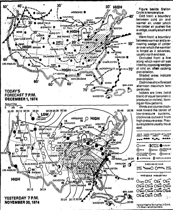
The weather in the eastern United States was a mess. A large low-pressure system was parked over Kentucky, which was affecting the weather all up and down the eastern seaboard. From Tennessee to the Great Lakes, and eastward through the mid-Atlantic, it was cloudy, cold, and windy. Higher altitude areas were facing a persistent wintry mix, while lower-lying areas experienced an unpleasant, cold drizzle. Visibility was poor. In the unsettled atmosphere, thunderstorms were popping-up here and there all through the mid-Atlantic region.
At Washington National Airport (now Ronald Reagan Washington National Airport), the winds were the biggest concern. The airport—still today—has only one runway suitable for jet airliners: runway 1/19. It runs north/south, which makes for easy takeoffs and landings when the winds are blowing (as they usually do) roughly from those directions . . . but it makes things much more challenging when winds blow across the runway from the east or the west.
On December 1, 1974, the winds at Washington National Airport were blowing from the east/northeast at about thirty miles-per-hour, with gusts recorded as high as fifty-six miles-per-hour. Around the time that Flight 514 was preparing to depart from Columbus, officials at Washington National decided that the crosswinds were becoming dangerous. They closed the airport to all incoming flights until conditions improved.
New Destination
Dulles Airport (Roger Wollstadt [CC BY-SA-2.0])At 10:36 a.m., after Flight 514 had been in the air for about ten minutes, air traffic controllers informed the flight crew that no landings were being permitted at Washington National Airport, and that all flights heading there were being held or diverted to Dulles International Airport (now Washington Dulles International Airport). After consulting with TWA dispatchers in New York, Captain Brock amended Flight 514’s destination to Dulles.
Dulles Airport is located in the western suburbs of DC on the border between Fairfax County and Loudoun County, Virginia—about twenty miles west of Washington itself. At the time, it had three runways. The two most-used were 1L/19R and 1R/19L, both (like National Airport’s main runway) running roughly north/south. A third runway, 12/30, runs northeast/southwest and can better accommodate traffic when the winds are blowing in unusual directions. On December 1, 1974, approaches were coming in on runway 12, against the eastern winds.
The Cleveland Air Route Traffic Control Center (ARTCC) cleared Flight 514 to proceed at an altitude of 29,000 feet to the Front Royal VOR navigational beacon, en-route to Dulles. At 10:43 a.m., Cleveland cleared the flight to descend to 23,000 feet and handed them over to the Washington ARTCC.
In the cockpit, Captain Brock turned control of the plane over to First Officer Kresheck. The crew discussed the approach to Dulles’s runway 12, and the possible routing they might receive from traffic control for the approach. They established contact with the Washington ARTCC, where controllers asked them to adjust their course due east (ninety degrees) to intercept the three-hundred degree radial of the Armel VOR navigational beacon. This would set them up for a direct approach to runway 12. They were cleared to descend to 8,000 feet, and the crew began to perform their preliminary landing checklist.
Misunderstanding
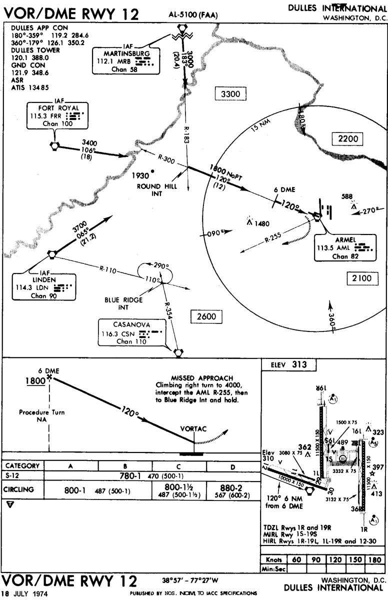
Runway 12 VOR/DME Chart (from the NTSB report)
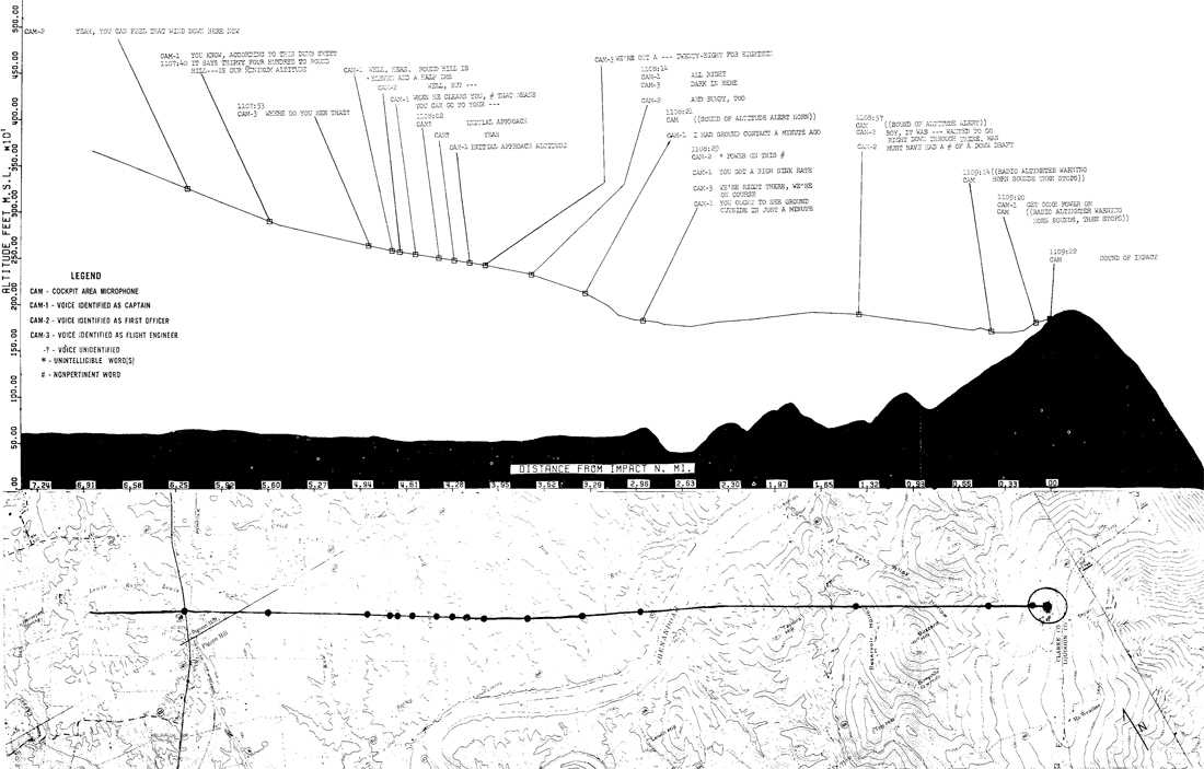
At 11:01 a.m., as Flight 514 passed through 10,000 feet, controllers cleared a further descent to 7,000 feet and instructed the crew to contact Dulles approach control. They did so, making contact with Merle W. Dameron, a twenty-year air traffic control veteran. Flight 514 continued its descent. Three minutes later, having reached the target altitude, Dameron radioed: “TWA 514, you are cleared for a VOR/DME approach to runway 12.”
The initial approach altitude on the VOR/DME approach to runway 12 was 1,800 feet, noted on the charts at six nautical miles from the Armel beacon (which is located on the Dulles airport property). Following receipt of approach clearance, Captain Brock noted to First Officer Kresheck that the approach minimums were 1,800 feet. Kresheck set the autopilot to that altitude, and the plane began to descend again. It was 11:05 a.m.
Two minutes into their descent, Captain Brock, who had continued consulting his charts, noticed an apparent discrepancy. The minimums were 3,400 feet until Round Hill, a location about twelve nautical miles from the Armel beacon. The cockpit crew discussed this, and agreed that their clearance from Dulles approach control permitted them to descend to their initial approach altitude—1,800 feet.
At 11:08 a.m., an altitude alarm sounded briefly in the cockpit, signalling that they had reached their target altitude of 1,800 feet. Less than a minute later, it sounded again, indicating that they had deviated from that set altitude (possibly due to turbulence or a downdraft). Records from the data recorder indicate that the plane had dropped nearly two hundred feet below its target altitude. At 11:09:14 a.m., another alarm sounded. It was a 500-foot radio altimeter warning, indicating that the plane was just five hundred feet above the ground.
Perhaps facing a sneaking suspicion that something was wrong, and that they should not have been within five hundred feet of the deck, Captain Brock ordered First Officer Kresheck to “get some power on” and get back up to 1,800 feet. Seconds later, at 11:09:20 a.m., the radio altimeter alarm sounded again, warning the cockpit crew that they were now only one hundred feet above the ground. It is not known if the cockpit crew realized then that something was terribly, terribly wrong, but if they did it was too late. Flight 514 crashed into Mount Weather, Virginia, less than two seconds later.
As this was happening aboard Flight 514, Dameron, the controller, noticed that the plane’s altitude was much lower than he expected it to be. At 11:09:54 a.m., he called to make sure his instruments were reporting correctly: “TWA 514, say your altitude.” There was no response.
The Crash
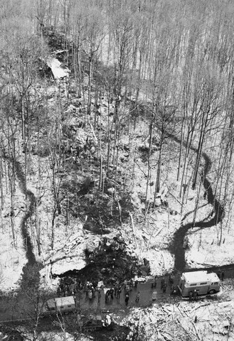
Debris Path (Bettman/Corbis)
Flight 514 made contact with the treetops to the west of the peak of Mount Weather, Virginia, at an altitude of about 1,700 feet.
The plane traveled about five-hundred feet, cutting a path through the trees, before impacting a rock formation. The impact with the rocks ripped the 727 to pieces, scattering debris over an area two-hundred feet wide and nearly one-thousand feet long and igniting several small, intense fires. There were no survivors.
Conditions at the crash site were snowy with visibility below one-hundred feet. Most likely, the cockpit crew did not see the mountain until they had already made contact with the trees.
The crash itself occurred in Clarke County, Virginia, but only a few hundred yards from the Loudoun County line. More than 150 fire and rescue personnel were dispatched to the scene from across the region, including personnel from Clarke and Loudoun. The Loudoun County Medical Examiner was responsible for recovering and identifying the victims. Recovery efforts were hampered by the weather, especially as several inches of snow accumulated in the following days.
The wreckage of Flight 514 was strewn across Blue Ridge Mountain Road (Virginia Route 601), which remained closed while recovery efforts continued. The crash also severed phone service to the Mount Weather facility—a then top-secret continuity of government facility—but due to its critical national security functions, C&P Telephone technicians restored service within two and a half hours while fire crews continued to work at the scene. That facility is now known as the FEMA Mount Weather Emergency Operations Center.
The Cause(s)
TWA 514 Crash Profile (NTSB)
The National Transportation Safety Board (NTSB) performed a full investigation of the crash of TWA Flight 514, but, unusually, was unable to come to a unanimous decision.
The majority position was that the probable cause was pilot error: the crew decided to descend to 1,800 feet when they should not have been anywhere below 3,400 feet. They cited as contributing factors that controller terminology was not sufficiently clear, and that altitude restrictions were not sufficiently clear on the VOR/DME approach chart.
A minority of the NTSB members at the time disagreed, stating that the probable cause was the Dulles approach controller’s failure to issue the appropriate altitude restrictions when giving approach clearance to Flight 514.
The disagreement seems to have boiled down to a question of whether or not Flight 514 was on a radar approach. Under the Federal Aviation Administration (FAA) regulations at the time, if the flight had been on a radar approach the controller would have been required to clearly state the acceptable minimum altitude when giving clearance. If the flight had not been on a radar approach, however, it would have been the pilots’ responsibility to know and maintain their minimums on their own without guidance from air traffic control.
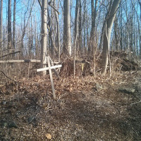
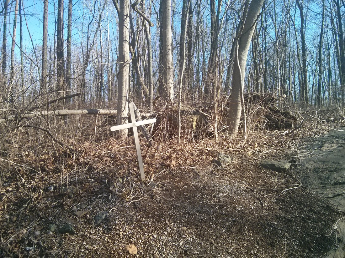
Trees 1-Year Later (C. Brown [CC-BY-SA-2.5])The sad irony is that the NTSB’s disagreement reflects the very discrepancy between what the cockpit crew and the controller understood about Flight 514’s status. At Dulles approach control, Dameron believed that Flight 514 was not on a radar approach, so he left it up to the pilots to know their minimums. Captain Brock and First Officer Kresheck, however, believed that they were on a radar approach, and believed that their approach clearance meant that they should descend to the approach altitude of 1,800 feet.
All of the men involved were competent professionals, and all believed that they were following the rules correctly. The NTSB investigation found that most pilots understood approach clearance to mean exactly what Flight 514’s crew thought it meant, while most controllers understood it the way Dameron did. Only six weeks earlier, on the exact same approach to Dulles’s runway 12, a United Airlines flight crew had also interpreted approach clearance as permission to descend, and only narrowly missed sharing Flight 514’s fate.
Although the FAA was aware of this persistent misunderstanding between pilots and controllers, no corrective measures were put in place until after Flight 514, and ninety-two lives, were lost.
Legacy
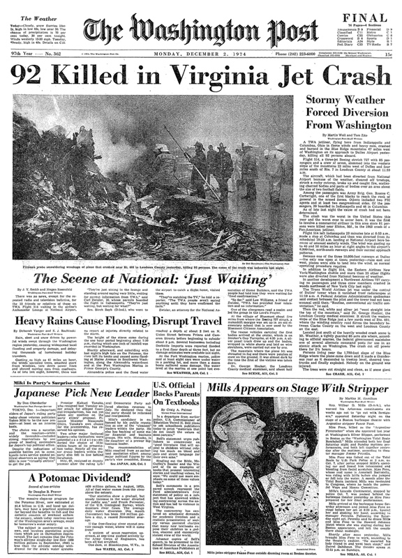
The Washington Post, Dec. 2, 1974
Ninety-two passengers and crew lost their lives when TWA Flight 514 crashed on Mount Weather, but, as in so many other air disasters, their deaths have not been in vain. Throughout the history of aviation we have made tireless efforts to learn from every accident. Today, air travel is safer than it has ever been, in part because we have tried to make sure that no deadly accident is repeated.
The NTSB made a number of recommendations in the aftermath of the Flight 514 crash, many of which have been implemented by the FAA and are still in-force today.
The Boeing 727 involved in this accident was fitted with a ground proximity warning system, but the pilots did not heed its warnings until it was too late. Many other airliners didn’t have such a system at all. The NTSB recommended that all commercial aircraft be equipped with such a system, the FAA accepted the recommendation, and by the end of 1975 all commercial aircraft flying in the United States had a ground proximity warning system.
The NTSB also recommended clarifying the federal regulations relating to the pilots’ responsibilities and actions following a non-precision approach clearance, and requiring that air traffic controllers issue clear altitude restrictions even during non-precision approaches. The FAA also accepted and implemented these changes; today, Flight 514 would have been told, “TWA 514, you are cleared for a VOR/DME approach to runway 12, maintain 7,000 until established on approach.” Also, the pilots’ manual now specifies that pilots are to maintain the last assigned altitude until formally established on an approach.
Lastly, the FAA made upgrades to the ‘ARTS III’ air traffic control system so that it would actively alert controllers when an aircraft deviates from its assigned altitude, adding another layer of protection and early warning should another plane begin to descend before it is safe to do so.
Thanks to these, and other improvements in the decades since, airline accidents categorized as ‘controlled flight into terrain’ have become vanishingly rare in the United States . . . to the point that they are practically unheard of. And that is exactly what we owe to the victims of every air disaster: a concerted effort to make sure that it doesn’t happen again.
Getting There
Memorial Location
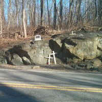
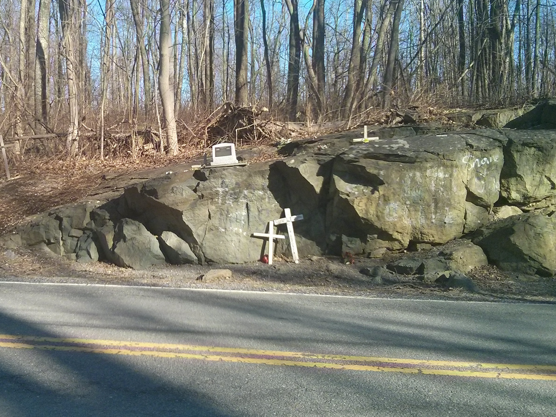
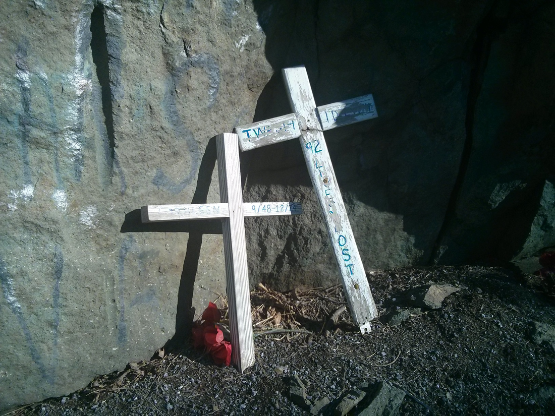
The rock outcropping where TWA Flight 514 made its catastrophic impact stands just feet from Blue Ridge Mountain Road in Clarke County, Virginia, less than three-hundred yards from the Loudoun County line. All evidence of the crash itself is long gone, the vast majority of which was removed during the investigation. Anything that remained would have long-since been overgrown and buried.
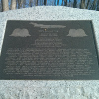
But a small stone marker stands upon the outcropping itself, engraved with the names of the ninety-two passengers and crew who lost their lives on the morning of December 1, 1974. Although the crash occurred over forty years ago now, regular visitors continue to leave flowers and other mementos at the site.
Whichever way you get to the memorial, please do not proceed down Ashley Woods Lane; it is private property. Also, do not enter or U-turn at the FEMA Mount Weather Emergency Operations Center, unless you enjoy unpleasant encounters with armed guards. Lastly, please be very careful crossing Route 601 to reach the memorial.
From U.S. Route 50: Head west on 50 (John Mosby Highway) and ascend the hill beyond the town of Paris, Virginia. At the crest of the hill, turn right on Blue Ridge Mountain Road (Virginia Route 601). After about six miles, you will reach the FEMA Mount Weather Emergency Operations Center. Continue past the center for about one mile and you will see the rock outcropping and memorial on your right. I recommend continuing just past the memorial and parking on the left at the top of Ashley Woods Lane.
From Virginia Route 7: Head west on 7 (Harry Byrd Highway) and ascend the hill to Snickers Gap, just past the turnoffs into the town of Bluemont, Virginia. At the crest of the hill, turn left on Blue Ridge Mountain Road (Virginia Route 601). Proceed about three and a half miles to Ashley Woods Lane on the right, which is where I recommend parking. The memorial is just past Ashley Woods on the left. If you reach the FEMA Mount Weather Emergency Operations Center, you have gone too far.
Check-Six.com. “In A Place That Doesn’t Exist.” Link.
U.S. National Transportation Safety Board. “Aircraft Accident Report, Trans World Airlines, Inc., Boeing 727-231, N54328, Berryville, Virginia, December 1, 1974.” Report No. NTSB-AAR-75-16, November 26, 1975. PDF Link.
“Weather Reports and Forecast.” New York Times, December 1, 1974: Sec. 1, Pg. 95.
Weil, Martin, and Tom Zito. “92 Killed in Virginia Jet Crash.” Washington Post, December 2, 1974: Pg. A1.
Scott Bradford has been putting his opinions on his website since 1995—before most people knew what a website was. He has been a professional web developer in the public- and private-sector for over twenty years. He is an independent constitutional conservative who believes in human rights and limited government, and a Catholic Christian whose beliefs are summarized in the Nicene Creed. He holds a bachelor’s degree in Public Administration from George Mason University. He loves Pink Floyd and can play the bass guitar . . . sort-of. He’s a husband, pet lover, amateur radio operator, and classic AMC/Jeep enthusiast.
X
Site Information
Off on a Tangent Website 26.0 “Sarah”
Scripturam veritas sunt quum anno Domini MCMXCV
(Writing the truth since A.D. 1995)
Tangent Theme:
26.0.48
Tangent Plugin:
6.0.111
Keyboard Shortcuts
Just type these sequences on the keyboard, or enter them in the search bar!

![A Similar Boeing 727 (Richard Silagi [GFDL (http://www.gnu.org/copyleft/fdl.html)])](https://www.scottbradford.us/wp-content/uploads/2015/05/twa514-twa727200.jpg)
![Dulles Airport (Roger Wollstadt [CC BY-SA-2.0])](https://www.scottbradford.us/wp-content/uploads/2015/05/twa514-dulles.jpg)
![Trees 1-Year Later (C. Brown [CC-BY-SA-2.5])](https://www.scottbradford.us/wp-content/uploads/2015/05/twa514-trees.jpg)